


Physical Geography and Geomorphology of Uganda
Uganda’s terrain features a broad plateau, flanked by volcanic mountain ranges to the east and west, and is dotted with numerous lakes and rivers. The nation sits primarily on elevated land and is especially noted for its rich water bodies, including the expansive Lake Victoria.
Topographical Overview
Uganda is a country of considerable topographical interest. While much of the country’s interior landscape shows a certain sameness due to the widespread development of well-marked erosion surfaces, dramatic contrasts emerge at the borders.
Western Region
On Uganda’s western frontier with the Democratic Republic of Congo lie the Mufumbiro volcanoes, the Ruwenzori Mountains, and part of the deep trough of the western rift. This rift valley contains Lakes Albert, Edward, and George. The relief contrasts are greatest in this region. From the high peaks of Ruwenzori to the arid flats around Lake Albert in the north, there is a vertical drop of nearly 45,000 feet.

Eastern Region
To the east, the approach to the Kenyan border is marked in the south by the massive Mount Elgon, and further north by the volcanic centers of Karamoja and the hill country of Dodoth adjacent to the Lake Rudolf rift. Although Mount Elgon rises to over 14,000 feet, its slopes are generally gentle. More impressive scenery is found in the deeply eroded volcanic remnants to the north, which rise abruptly from otherwise monotonous plains.
Elevation and Land Surface
Most of Uganda lies between 3,000 and 5,000 feet above sea level. The lowest part of the country is the valley of the Albert Nile near Nimule on the Sudan border, which sinks to about 2,000 feet. The highest point is the summit of Mount Stanley in the Ruwenzori, rising to nearly 16,800 feet.
Geologic History and Surface Evolution
Very little remains to indicate the history of the land surface before Tertiary times. Since at least the Karroo period, sub-aerial erosion driven by continental cyclic changes due to isostatic recovery has been dominant.
Powerful and recurrent warping and rifting, beginning likely in Tertiary times and continuing into the Quaternary period, dramatically transformed Uganda’s landscape. These tectonic movements are most pronounced in the west, where rift-related activity was strongest.
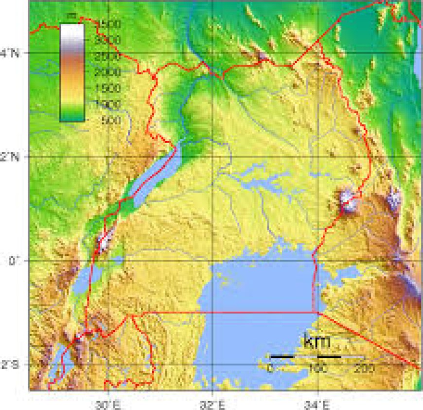
 Map of Uganda: Photo by Maphill
Central and Southeastern Uganda
In contrast, the central and southeastern regions have experienced little deformation since pre-Cambrian times. The scenery here typically consists of flat-topped hills separated by broad, open valleys filled with extensive papyrus swamps. This characterizes much of Buganda and the Lake Victoria zone.
The hilltops are covered with thick, hard laterite over deeply weathered ancient rocks—remnants of the Buganda erosion surface, likely from the Cretaceous period. This surface currently stands between 4,250 and 4,400 feet above sea level. Lower remnants appear along the lake shore and in the Sese Islands, due to relative downwarping.
Erosion Surfaces and Morphological Trends
Similar flat-topped hills and open valleys, along with laterite deposits, allow tracing of erosion surfaces westward into more tectonically unstable areas. The Buganda surface rises gradually toward the rift:
-
Koki: ~4,600 feet
-
Rakai & Mubende: ~5,000 feet
-
Ankole: ~6,000 feet
-
Southwestern Uganda: 7,000–8,000 feet
The irregularities in these surfaces are due to either original relief differences or varying resistance of underlying rocks. For example, the same surface lies higher on resistant Karagwe-Ankolean argillites or quartzites than on less resistant schists and granites.
Lower Erosion Surface
Below the upper surface, separated by steep slopes, lies a zone of re-cemented laterite—evidence of a pre-Miocene erosion cycle. In Buganda, Ankole, and Kigesi, this produced an etchplain or valley-floor surface. In northeastern Bunyoro, Lango, Teso, and Acholi, this becomes a vast, monotonous plain broken by isolated inselbergs and seasonal stream beds.
In the north, this surface is associated with the Aswa-Nile system rather than former westward-flowing drainage. Towards the east, deeply dissected Tertiary volcanic remnants frame the northern plains, while to the west of the Albert Nile, upwarped platforms rise toward the Congo watershed in West Nile.
Tectonic Movements and Volcanic Activity
Movements associated with the western rift began in the Tertiary period and continued through the Pleistocene. The pre-Miocene surface was downfaulted in stages, leading to the accumulation of thick lacustrine sediments within the developing trough.
Ruwenzori Uplift and Rift Shoulder Warping
Simultaneously, the Ruwenzori block was uplifted to nearly its current height. Rift shoulders were warped upward, causing elevated erosion surfaces compared to those farther east. Intermittent rift fault movements continued until the current structural pattern was established in late Pleistocene times.
Volcanic Features
Volcanic activity accompanied later rift movements. Evidence includes explosion crater zones around Fort Portal, on both sides of the Kazinga Channel, and in the Mufumbiro Mountains of extreme southwestern Uganda. The area features lava flows and craters, indicating prolonged volcanic development.
Uganda's Elevation, Mountains, Lakes, and Rivers: A Geographical Overview
Land Area and Elevation Distribution
Uganda features a varied landscape with a wide range of elevations. Below is the distribution of land according to altitude:
| Elevation Range | Percentage of Total Land Area |
|---|---|
| Below 3,000 ft | 9.3% |
| 3,000–5,000 ft | 84.0% |
| 5,000–7,000 ft | 5.4% |
| Over 7,000 ft | 1.3% |
Note:The area includes Uganda’s territorial waters on Lakes Victoria, Albert, and Edward. 7,000 ft is approximately the upper limit of permanent habitation.
| Region | Area (sq. km) |
|---|---|
| Karamoja | 27,528 |
| Madi | 10,262 |
| Uganda Total | 241,038 |
Uganda’s Major Mountain Ranges
Ruwenzori Mountains (Over 10,000 ft)
Only the highest peaks of each mountain in the Ruwenzori range are listed below. There are 21 named peaks over 15,000 ft in the Ruwenzori, with 9 exceeding 16,000 ft. The permanent snow line lies around 14,700 ft.
| Mountain (Ruwenzori) | Height (ft) |
|---|---|
| Margherita (Stanley) | 16,763 |
| Vittorio Emmanuele | 16,042 |
| Speke | 15,889 |
| Jackson’s Summit | 15,650 |
| Umberto | 15,740 |
| Iolanda | 15,470 |
| Gessi | 15,470 |
| Sella | 15,179 |
| Humphreys | 15,021 |
| Luigi di Savoia | 15,021 |
Other Significant Mountains in Uganda
| Mountain | Height (ft) |
|---|---|
| Elgon | 14,178 |
| Mubiyi | 13,810 |
| Muhavura | 13,540 |
| Sabinio | 11,960 |
| Mgahinga | 11,400 |
| Moroto | 10,116 |
| Kadam | 14,720 |
| Kihuma | 10,067 |
| Portal (Debasien) | 14,405 |
Major Lakes of Uganda.
The country’s lakes play a vital role in supporting both biodiversity and the economy, though they face growing threats from environmental degradation. This region encompasses several countries surrounding the African Great Lakes, including Burundi, the Democratic Republic of the Congo, Kenya, Malawi, Rwanda, and Tanzania.
Among these lakes, Lake Victoria, Lake Albert, and Lake Edward partially lie within Uganda’s borders. All three contribute to the flow of the White Nile, a major tributary of the Nile River. Nearly all of Uganda falls within the Nile basin.
| Lake | Total Area (sq. miles) | Area in Uganda (sq. miles) | Height Above Sea Level (ft) | Max Depth (ft) |
|---|---|---|---|---|
| Victoria | 26,828 | 11,479 | 3,720 | 270 |
| Albert | 2,059 | 1,124 | 2,030 | 168 |
| Edward | 850 | 249 | 2,995 | 384 |
| Kyoga & Kwania | 790 | 790 | 3,400 | 24 |
| Salisbury | 119 | 119 | 3,435 | 95 |
| George | 95 | 95 | 2,997 | 10 |
Major Rivers in Uganda (Length in kilometers)
Uganda hosts several important rivers, with the Nile—especially the Victoria Nile and Albert Nile—being the most prominent as it flows through the country's north. Other notable rivers include the Katonga, Kafu, Sezibwa, Achwa, Kagera, and Semliki.
| River | Length (km) |
|---|---|
| Victoria Nile | 285 |
| Albert Nile | 223 |
| Aswa–Moroto | 196 |
| Mayanja–Kato | 145 |
| Dopeth–Okok | 135 |
| Katonga | 114 |
| Pager | 110 |
| Mpologoma–Malaba | 108 |
Conclusion
Uganda’s diverse and dramatic physical landscape is a direct result of its complex geological history, tectonic movements, and long-term erosion processes. From the towering Ruwenzori Mountains to the gently rolling hills of Buganda, and the volcanic remnants of Karamoja to the flat plains of Acholi, the country's relief features are both varied and significant. Understanding these geomorphological and tectonic patterns not only provides insight into Uganda's physical geography but also enhances appreciation of its unique environmental heritage. This diversity continues to shape natural ecosystems, climate patterns, and human settlement across the region.