


What-are-fronts-types-and-effects
Learn about weather fronts, their types, and their effects on global weather patterns. Explore cold fronts, warm fronts, occluded fronts, polar fronts, and inter-tropical fronts, along with associated weather changes and impacts.
FRONTS
What is a Front?
A front is a narrow zone of separation of air masses which have different characteristics in terms of temperature and humidity which are brought together but do not mix freely. Whenever two air masses which have different characteristics in temperature and humidity meet, there will be a slow ascent of warmer air over the colder air or a more rapid forcing of warm air upwards by cold air pushing in. It follows that adiabatic cooling of the warm air will occur and ultimately condensation will take place.
Thus, fronts are among the most important features of weather in both temperature and equatorial zones. There are three types of fronts discussed below.
Cold front
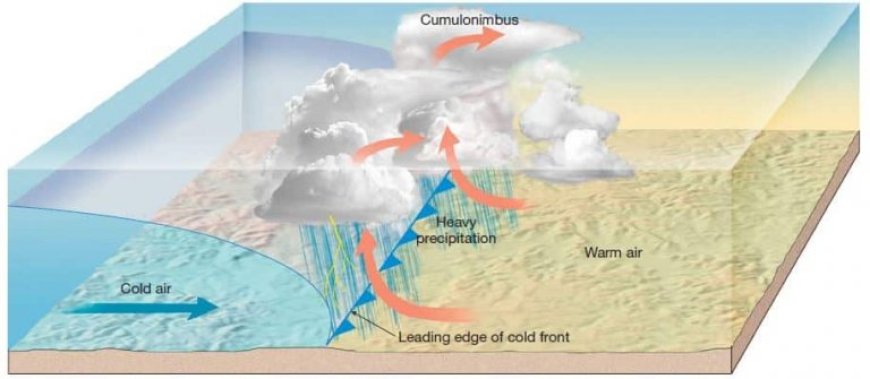
A cold front occurs when cold air invades a zone of warm air. The colder air being heavier and denser, remains in contact with the ground and forces the warmer air to rise over it. The slope of the cold front is steep due to the rapid cooling of the warmer air. As the advising cold air layer lifts the warm unstable air, the warm air develops strong conventional activity, and on reaching the condensation level, cumulo- nimbus clouds are formed. Thus, heavy precipitation accompanied with thunderstorms is often associated with cold fronts.

As a cold front approaches, atmospheric pressure normally drops. As the cold front moves on by atmospheric pressure rises and the winds shift direction. The passage of the front is often accompanied by the heaviest precipitation and the strongest and gustiest winds. Occasionally, however, a line o thunderstorms may develop, out ahead of a cold front. This line is called a squall line and it produce heavy rain and strong, gusty winds.
Warm front.
A warm front marks the region where warm air is replacing cold dry air. Warm air moves into a region of cold air. Here, again the cold dry air mass remains in contact with the ground and the warm air mass is forced to rise. An average warm front has a more gentle slope than that of a typical cold front. As a warm front advances, warmer air glides up and over the colder, denser surface air. This process called over-running, produces widespread cloudiness and precipitation well in advance of the front's surface position. Typically, clouds are of strato-form type. Generally, warm fronts commonly represent stable atmospheric conditions.

Warm fronts are best developed in winter. As a typical warm front approaches, the atmospheric pressure drops and high, wispy cirrus clouds form 12 to 24 hours ahead of the front. These clouds give way to thicker and lower clouds such as cirrostratus and altostratus. As the warm front moves closer, cloud level descends and steady rain, snow, sleet, or freezing rain may fall from nimbostratus clouds into the cold air ahead of the front. Just before the front passes, there may be low stratus clouds and fog. As the warm front passes, the air temperature and humidity rise, the atmospheric pressure stops falling, the winds shift, the rain ends, and the fog dissipates. However, these weather changes are less noticeable than those of a typical cold front.
Occluded front.
Cold fronts usually move faster than warm fronts. Consequently, when a cold front overtakes a warm front, a new front, called an occluded front, forms. .An occluded front occurs when cold air advances into a warm air mass, cutting it off completely from the ground. The warm air thus lies above while the cold air forms a 'cushion' below.
There are two types of occlusions:-
Warm occlusion: If the warm air is lifted off the ground at a warm front, a warm front occlusion is formed.
FRONTAL ZONES
Two main frontal zones can be distinguished on the earth's surface, the polar front and the inter-tropical front.
The polar front.
The polar front is the boundary area, which separates the polar air masses from the tropical air masses. The position of the front varies from season to season. In winter, the front is situated well to the south and extends approximately from the central-eastern seaboard of North America to Spain.
In summer, the front moves northwards and stretches from Newfoundland across Norway. Over the large continental regions in the Northern Hemisphere, the polar front is considerably displaced by the radiation effect of the landmasses. In the Southern Hemisphere, the front is less evident as it lies over the great oceans of the south.
The inter tropical front.
This region, which lies in the equatorial belt, is where trade winds (air masses) from the northern latitudes meet the trade winds from the southern latitudes. The Fig 20.005 below shows the mean position of the inter-tropical front in January and July.
The air masses which converge towards the inter-tropical front over the oceans are moist in the lower layers and relatively dry at higher levels. Usually the lapse rate slightly exceeds the saturated adiabatic lapse rate. If such air masses are slowly lifted by the general low-level convergence, instability results and large cumulus form. These clouds will continue to develop into cumulonimbus and will give rise to intense shower and thunder conditions.
DEPRESSIONS AND ANTICYCLONES
Depressions
These are systems of air masses whose isobars form an oval or circular shape, where pressure is low in the center and increases towards the periphery.

Life cycle of a polar front depression
There are two types of depressions:-
1. Temperate cyclones or depressions
2. Tropical cyclones.
Temperate cyclones or depressions.
These arise in the belt of westerly winds and are caused by the mixing of cold air from the Polar Regions with warm humid air from tropical regions. They are dominantly located in temperate regions between 40° - 60° North and South of the equator for example in North West Europe, British Columbia, Alaska and the coast of Chile.
Formation
Depressions originate as a direct result of the interaction between two contrasting air masses, one of tropical and other of polar origin. This occurs at the polar front. As earlier stated when two air masses meet with contrasting temperature and humidity, they cannot mix freely and a depression develops.
Development of a temperate cyclone.
A long the polar front, cold polar air moves in a general easterly direction. The frictional effect of the two air masses causes a wave to develop.The wave bulges into the colder air and gets larger. Pressure falls at the tip of the wave and an anti- clockwise circulation of winds blows around this low pressure point in the Northern Hemisphere.
As the bulge develops, the warm air rises up over the colder air at the front of the bulge. This is called the warm front. At the rear of the bulge, the cold air forces its way under the warm air. This is called the warm sector.
The warm front is much more gently sloping than the cold front. Eventually the cold front catches upwith the warm front and lifts it off the ground. It then becomes an occluded front and soon dies out.

Characteristics of temperate cyclones or depressions.
1. They are located in the temperate regions between 40° - 60° North and South of the equator.
2. Lowest pressure is near the center of the depression.
3. Highest pressure is at the periphery of the system.
4. Air circulates around the point of low pressure. The circulation is clockwise in the southern hemisphere and anti-clockwise in the northern hemisphere.
5. Winds blow towards the centre, which is a zone of low pressure.
6. They develop over sea or ocean water.
7. They affect small area which may not reach 150 km off the coast.
8. It is a cyclic form of circulation capable of movement, growth and decay.
Weather associated with depressions.
· At the war front where warm air rises over the cold air, the following conditions are experienced;
· Warm air rises over the cold air leading to condensation and the formation of cirrus clouds and rainfall. The rainfall begins as light showers, which progressively become heavier as the warm front passes.
· The winds blow in an easterly or southeasterly direction.
· The winds are accompanied by fairly low temperatures.
· The cirrus clouds are replaced by a stratiform stratus and cumulus clouds, which cover the whole sky and become lower as the front at the ground approaches the observer.
· Much of the precipitation starts to fall as snow.6.With the passage of the warm front and arrival of the warm sector, rain ceases apart from drizzles, temperatures rise and stable stratiform clouds prevail.
· Pressure falls quite markedly.
· Winds change direction from easterly to westerly or southwesterly on the arrival of the warm sector.
· Advection fog is common in winter as the warm front passes which reduces visibility.
Weather at the cold front.
The cold front coder air forces its way under the warm air. This is associated with the following weather conditions.
· Winds change direction from south west to north west.
· Temperatures fall.
· Pressure rises.
· Short but heavy falls of rain occur.
· Once the cold front passes, there is rapid improvement in visibility.
· Temperature inversion is a common phenomenon.
TROPICAL CYCLONES OR TROPICAL DEPRESSIONS.
A tropical cyclone is a large scale storm with heavy rainfall and winds which rotate anti-clockwise in the northern hemisphere and clockwise in the southern hemisphere around and toward a low atmospheric pressure center. They are some of the most deadly and most destructive storms on the earth's surface.
 Development of a Tropical Cyclone
Tropical cyclones are given names where they occur for example Will Willies in Australia, typhoons in the Philippines, Japan and in the seas off China, cyclones in the Indian Ocean and tornados and hurricanes in America, the Caribbean and off the Pacific coast of Mexico. In the USA hurricanes are often given names e.g. Hurricane Katrina.
Typhoons are violent tropical cyclones with a velocity of over 160 Km per hour. They cause great menace and damage to ships and buildings in coastal areas. Torrential rains, lightning and thunder accompany them. They occur mainly off the South China Sea.
Tomadoes are air spirals seen as funnel clouds at a tremendous speed of 120-500 Km per hour, and devastate everything in their passage. They are violently rotating column of air extending from within a thundercloud down to ground level. The strongest tornadoes may sweep houses from their foundations, destroy brick buildings, toss cars and school buses through the air, and even lift railroad cars from their tracks.
They vary in diameter from tens of meters to nearly 2 km, with an average diameter of about 50 m. Most tornadoes in the northern hemisphere create winds that blow counter clockwise around a center of extremely low atmospheric pressure. In the southern hemisphere, the winds generally blow clockwise. Tornadoes occur mainly in southern USA. They also occur in many other countries, including China, India, Russia, England, and Germany.
Formation of tropical cyclones.
Tropical cyclones develop along the inter-tropical front where the trade wind air masses converge. They form over all the tropical oceans except the south Atlantic. They are mostly experienced in latitudes 300 north and south of the equator. These air masses over the oceans have moist lower layers but drier upper layers. When two such air masses meet, a wave develops in much the same way as waves are created on the polar front. This results in a drop of pressure at the center of the system. An anticlockwise circulation of wind blows around this low pressure point in the Northern Hemisphere. The circulation is clockwise in the southern hemisphere. The wind moves at high speed of over 120 Km per hour.
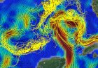
 Formation of a Tropical Cyclone (cradit BBc Image)
The energy of a tropical cyclone depends upon an abundant supply of moisture in the warm tropical air and the consequent latent heat set free by the condensation of the water vapour. The highest winds surround the calm centre or 'eye of the storm'. This calm centre is about 10 to 15 miles in width. As long as there is unlimited supply of moisture at the base of a developing cyclone and latent heat released by condensation is maintained, intense circulation of air will continue. Once overland tropical cyclones weaken and eventually die out.
Characteristics of tropical cyclones
· They develop on either side of the equator usually between 100 and 20° latitude and rarely if ever between 50 North and South of the equator where the Coriolis force is extremely weak.
· They originate over ocean and sea water surfaces with high temperatures of at least 27° C. They never originate overland surfaces.
· They mainly occur over the western region of the oceans where the trade winds have journeyed for a long passage over waters having the highest sea-surface temperatures.
· Pressure is lowest at the center or the 'eye' and increases towards the periphery. The pressure in the central part commonly falls to 920-900 millibars
· They are affect small areas.
· They move westwards over oceanic surfaces and affect eastern coastlands e.g. Australia, China, India, Madagascar, Haiti, Dominican Republic, Pakistan, and the eastern states of Florida, New Orleans, as well as the Gulf Coast of Louisiana, Mississippi and Alabama in USA.
· The tropical cyclone is characterized by a central 'eye' in which calm prevails. In the eye, air descends from high altitude and is adiabatically warmed. The eye is surrounded by a violent periphery.
· They are violent revolving storms. They are one of the most powerful and destructive storms affecting the earth's surface. The speed of the wind is between 120 to 200 Km per hour and higher.
· The curve followed by tropical cyclones is approximately hyperbola.
· Air circulates in an anti-clockwise direction in the northern hemisphere and clockwise in the southern hemisphere.
· Winds blow towards the center characterised by a vortex, which is a rough peripheral zone.
· In the northern hemisphere tropical cyclones are most frequent in August and early September while in the southern hemisphere they are most active in February and March. It should be noted however that they are relatively infrequent in the southern hemisphere.
· They move slowly so that their passage over any point may take at least 10-12 hours.
· The outline is circular and consistent.ble of movement, growth and decay.
Weather associated with a tropical cyclone.
Before the arrival of the tropical cyclone, the air becomes still, and temperatures and humidity are high. As the front of the vortex arrives, gusty winds develop. When the vortex arrives, violent spiral winds which surge upwards and often reach a speed of 250 kilometers per hour develop.
The upward surge of warm, humid air over sea surfaces results into condensation and the formation of a dense cloud cover of cumulus and cumulo-nimbus nature. The dense cloud cover gives rise to very intensive rainfall accompanied by lightning and thunder. The most intensive rainfall is experienced just outside the ring of strongest winds in the inner part of the vortex or eye.
The dense cloud cover and torrential rain reduce visibility to a few meters.
Cyclones originate over water with high sea-surface temperatures that are over 27°C. They are thus associated with high temperatures.
The high temperatures lead to high evaporation rates resulting into high humidity.
The eye of the tropical cyclone is occupied by calm, subsiding air with light winds.
The arrival of the vortex brings a change in the direction of wind which now blows from the opposite direction to that of the front of the vortex.
Effects of tropical cyclones in areas where they occur.
Destruction of life and property.
Tropical storms have led to destruction of life and property in a number of areas. In 1985, 10,000 people were killed and over 25,000 were made homeless in Bangladesh, in 1990, over 200 people were killed and 1,400 villages destroyed in India while in 1994 in China over 800 people drowned due to a cyclone. Other areas affected by such storms include West Indies, Gulf of Mexico, Madagascar, Haiti, Vietnam, Caribbean Sea, Philippine Islands, China, Japanese Islands, Bay of Bengal, Fiji Islands and Florida (USA). In all the above areas there is destruction of power lines and crops on land while over water there is capsizing of boats and others are tossed ashore.
Flooding and its related problems.
A tropical storm can cause water to move land ward in a great wave called a storm surge. This kind of wave can cause the water level to rise 20 feet or more within few minutes. Few places on coastal Islands are as high as 20 feet. This therefore results into automatic flooding. Flooding has an effect of destroying life and property. Floodwaters swept New Orleans, Louisiana, after a storm surge from Hurricane Katrina breached the city's levees in August 2005. About 80 percent of the city was flooded by a toxic sewage, decomposing bodies, and industrial waste, prompting a complete evacuation of the city. Flooding is associated with spread of water borne diseases such as cholera and diarrhea e.g. in Pakistan, India and Bangladesh.
Destruction of crops which leads to famine.
In Bangladesh, most of the proteins in the diet of over 100 million persons come from fish. The loss of the total fishing capacity is a pointer to a disastrous famine. The flooding of farmers fields also means no harvests and hence famine.
Heavy rains and landslides
Floods and landslides from heavy rain are among the leading cause of hurricane and tropical storm deaths. In October 1998 Hurricane Mitch's torrential rain caused floods and landslides that killed more than 9,000 people with another 9,000 missing and presumed dead in Central America.
Winds associated with depressions
Fohn or Chinook wind
This is a warm dry wind, which blows down the leeward slopes of mountains in the Alps of Switzerland and Austria, along the eastern side of the Rocky Mountains in USA and Canada and Southern Alps of New Zealand.
It occurs when a depression on the leeward slopes forced air to move up and over mountain barriers. As the air moves up the slope of the windward side of a mountain, it is cooled adiabatically and if the vertical movement is large, enough condensation takes place leading to the formation of clouds known as the fohn wall or chinook arch. These clouds give rise to precipitation.
When the wind reaches the northern slopes or leeward slopes, it will have lost most of its moisture and it is warmed adiabatically at the dry lapse rate. This dry wind is known as the fohn or chinook.
The fohn wind has an effect of raising temperature by 8° to 11°C. This wind is useful in spring when it is at maximum. It is used in melting the winter snow and thus makes pastures available for grazing. It is also useful in autumn the season of second greatest frequency in ripening the crops especially the grapes. In USA and Canada, strong and frequent Chinooks mean mild winters.
ANTICYCLONES
An anticyclone is a mass of air whose isobars form a similar pattern to that of a depression, but in which atmospheric pressure is high at the center, decreasing towards the periphery of the system.
 Image of the Anticyclines.
Anticyclones are large and often affect whole continents. They form outside the tropics at the horse latitude where air is subsiding. The subsiding air is light and variable and tends to move outwards from the center. Anticyclones are divided into two main groups, cold and warm. The warm anticyclones are characterised by cold dense air in the lower troposphere with relatively warm air above a level of about 1000 feet. Cold anticyclones on the other hand are relatively shallow features are related to surface chill of the Polar Regions.
Characteristics of anticyclones
· Highest atmospheric pressure occurs at the center and decreases towards the outside.
· They develop on land mainly at the sub-tropical high pressure or the horse latitude. They have a circular type of circulation.
· Wind circulation is clockwise in the northern hemisphere and anti-clockwise in the southem hemisphere.
· Winds blow outwards from the center to the periphery.
· Many anticyclones often move slowly or remain stationary for a long time before fading out.
· Anticyclones move northwards as compared to cyclones which move westwards.
· They are a cyclonic circulation capable of movement, growth and decay.
Weather associated with anticyclones
1. Inversion of temperature is common especially in the cold anticyclones.
2. Some few clouds form giving rise to little rainfall and drizzles. Anticyclones are associated with descending air, which is warmed adiabatically. This condition results in no or very low precipitation in summer because the subsiding air is unfavourable to cloud formation.
3. In winter, anticyclones are associated with light clouds or clear skies.
4. Radiation fog and smog accompanied by frost with temperatures inversion tend to be persistent in winter.
5. Winds are light.
6. Dry warm and sunny summers, but fog is common near and over the seas.
Table of Key Facts
| Aspect | Details |
|---|---|
| Definition | A front is a boundary between two air masses with different temperature and humidity levels. |
| Types of Fronts | Cold front, Warm front, Occluded front |
| Cold Front Characteristics | Rapid uplift of warm air, steep slope, cumulo-nimbus clouds, heavy precipitation, thunderstorms. |
| Warm Front Characteristics | Gentle slope, widespread cloud formation, steady rain, stable atmospheric conditions. |
| Occluded Front Characteristics | Occurs when a cold front overtakes a warm front, lifting warm air off the ground. |
| Frontal Zones | Polar front (boundary between polar and tropical air masses), Inter-tropical front (where northern and southern trade winds meet). |
| Depressions | Low-pressure systems causing cyclonic weather patterns. |
| Anticyclones | High-pressure systems associated with clear skies and dry weather. |
| Tropical Cyclones | Large-scale storms with high winds, heavy rainfall, and destructive effects. |
| Effects of Fronts | Precipitation, thunderstorms, wind changes, and temperature shifts. |
Frequently Asked Questions (FAQs)
Q1: What is a weather front?
A weather front is a boundary that separates two different air masses with distinct temperature and humidity characteristics.
Q2: What happens when a cold front passes?
A cold front leads to a drop in temperature, heavy precipitation, strong winds, and sometimes thunderstorms due to rapid uplift of warm air.
Q3: How does a warm front affect weather?
A warm front brings gradual warming, steady precipitation, and layered cloud formation as warm air glides over cold air.
Q4: What is the difference between a cold front and a warm front?
A cold front occurs when cold air pushes into warm air, leading to rapid weather changes, while a warm front forms when warm air moves over cold air, resulting in gradual changes.
Q5: Why do occluded fronts form?
Occluded fronts form when a fast-moving cold front overtakes a slower warm front, lifting the warm air mass completely off the ground.
Q6: What are the main global frontal zones?
The two main frontal zones are the Polar Front (between polar and tropical air masses) and the Inter-Tropical Front (where trade winds from both hemispheres meet).
Q7: How do tropical cyclones form?
Tropical cyclones develop over warm ocean waters near the equator, where moist air rises, cools, and forms intense storms with rotating wind patterns.
Q8: What are the effects of weather fronts on human activities?
Weather fronts impact agriculture, transportation, and daily life by causing precipitation, storms, temperature changes, and wind shifts.
Q9: Why are depressions important in weather patterns?
Depressions create unstable weather conditions, leading to storms, wind shifts, and precipitation.
Q10: What are anticyclones, and how do they differ from depressions?
Anticyclones are high-pressure systems associated with dry, calm weather, whereas depressions are low-pressure systems that bring storms and precipitation.