


River Rejuvenation: Causes, Effects, and Landforms Explained
Discover the concept of river rejuvenation, its causes, and its impact on landforms. Learn how tectonic activity, sea level changes, and increased river discharge contribute to renewed river erosion. Explore examples of rejuvenated rivers in East Africa, including the Nile, Tana, and Rwizi, and their significance in hydroelectric power, agriculture, and tourism.
What is river Rejuvenation?
Rejuvenation refers to the renewed erosive activity of a river. The erosive activity is increased due to increase in the river's energy. A river's energy may increase by the uplift of land over which it flows so that due to increased steepness, it begins to cut or erode into its channel once more. With the on set of fresh down cutting or vertical erosion, the stream is said to be rejuvenated. Some slight rejuvenation may occur in the upper parts of a river's course but most of them occur in the old or lower stages.
Many rivers, which flow into the Indian Ocean, were rejuvenated during the Quaternary glaciation when the sea level fell world wide. Deep channels of rivers Tana, Pangani and Rufigi can be traced for several kilometres in the ocean floor, where they cut deep into the coral limestone under the sea. Elsewhere, small streams, which were also rejuvenated, cut long narrow inlets through the corals. These narrow inlets have now been drowned by the post-glacial rise in sea level. Natural harbours such as Mombasa, Tanga, Dar-es-salaam and Mwtara are located in such inlets.
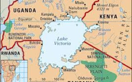
In the interior many of the rivers, which flow into Lake Victoria, have similarly been rejuvenated, the most notable being rivers flowing across the Kano plains of western Kenya such as Nyando, Ngaila, Sondu and Yala. Small short streams, which originate from the northern watershed of Lake Victoria and flow into the lake also show evidence of rejuvenation e.g. Lugogo, Nakivubo and Kitante streams have cut deep valleys in their old wide valleys.
Causes Of River Rejuvenation
Earth movements involving uplift, down faulting and warping. Faulting for example leads to the formation of scarps with steep slopes, which if crossed by a river will increase its speed, energy and erosive ability. In western Uganda, examples of rejuvenated rivers include Rwizi, Birira, Mpanga, Kafu, Nkusi and Hoima.
Uplifting of the eastern rift valley shoulder of the Albert rift valley, back-tilted western Uganda, resulting in not only drainage reversal and back pounding of the rivers which originally flowed westwards into the Atlantic, but also caused rejuvenation of the rivers of western Uganda.
In west Nile especially in Nebbi and Arua, many rivers have also been rejuvenated by the tilting of the land associated with the formation of the rift valley. Rivers like Nyagak and Anyau are examples of rejuvenated rivers. Tilting towards the east in Karamoja rejuvenated many rivers such as Pager, Moroto and Tochi.
Negative change in the base level or a fall in the sea level. A base level is the lowest level to which a river can erode a land surface such as its bed. it is an imaginary line extending from the river mouth beneath the land below which the river cannot erode. Sea level on the other hand refers to the surface level of the sea or ocean. When the level of the sea or lake falls, the river renews its down cutting until it reaches a new base or sea level. This is mainly so because of increased gradient of the river's channel.
Increase in the amount of water in the river. The increase may be brought about by increased rainfall, a tributary joining the main river, melting of ice caps on high mountains like Kilimanjaro and Kenya, and by river capture. In Kenya, River Tivi was rejuvenated due to the capture of the Rejuvenation results in increase in the rivers ability to erode by hydraulic, corrosive, comosive and attrition methods described on page 190. These processes lead to the formation of thefollowing landforms.
Formation of knick points
A knick point is a break of slope in the long profile of a river valley. It marks the point where rejuvenation started. The knick points may result from increase in discharge of a river due to river capture which results in renewed under cutting of the river bed. They are associated with waterfalls and rapids e.g. Gogo falls on river Kuja in western Kenya.
Paired river terraces
These are step-like or bench-like cuts on the sides of a river valley covered by a layer of gravel and other alluvial deposits. When a river renews its erosive activity in the old stage, it sinks into a new channel leaving part of the former flood plain well above the present river level to form paired river terraces. They are of equal height on either side of the valley. If renewed rejuvenation takes place, the process is repeated and second pair of terraces is formed at a lower level than the first. The paired river terraces mainly result from a negative change in the base level e.g. along rivers Ngaila and Nyando in Kenya and Semliki and Kafu in western Uganda.
Incised meanders
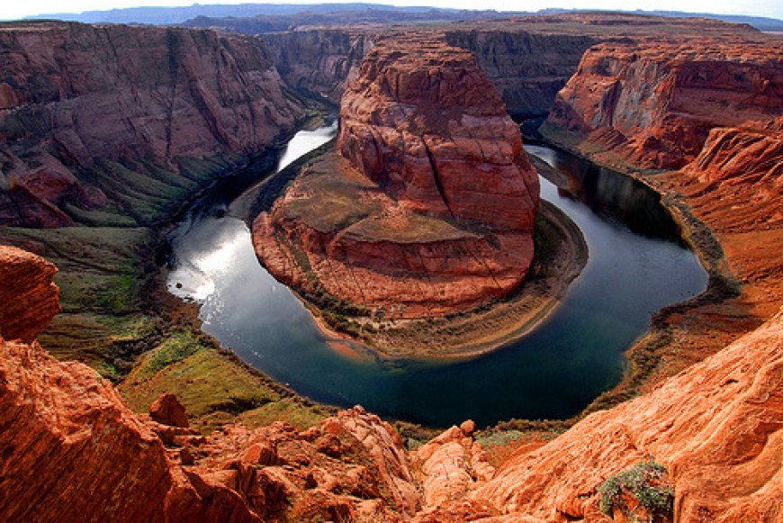
An incised meander is the curved bend of a river whose valley floor has been cut into or incised so that the river now winds between steep valley walls. Most incised menders result from rejuvenation of an already meandering river due to fall in the base level. There are three types of incised meanders, the ingrown, the entrenched and the abandoned meanders.
Ingrown meanders.
These are incised meanders with asymmetrical valley cross profile that is alternate steep sides with undercut slopes facing alternate gentle sides with large slip-off slopes. Ingrown meanders develop on resistant rocks and where the base level falls gradually, hence the meanders tend to shift laterally as they are incised e.g. meanders on River Rwizi in Mbarara, River Mwachi north west of Mombasa and the neighbouring Kombeni and Cha Shimba rivers.
Entrenched meanders
These are incised meanders with a steep sided symmetrical cross-profile. Erosion is equally distributed throughout the sides of the valley. This type develops on weak rocks and where the base level falls quickly, causing rapid vertical incision e.g. on rivers Mara and Kuja in western Kenya.
Abandoned incised meanders
These are meanders formed by rejuvenation along the flood plains during the formation of ox- bow lakes. The river cuts a new channel leaving the adjacent spur to form an isolated hill known as a meander score. Abandoned meanders form minor and short tributaries for example on the Kano Plains of Kenya.
Valley within a valley or rejuvenation gorge.
Where rejuvenation was fairly rapid and a fall in base level quite large, the effect is the production of a steep sided rejuvenation gorge within the former valley, the valley in narrower than the original valley as shown in Fig 12.036. Examples include the gorge at Murchison falls in Uganda the gorges on rivers Malewa and Gilgil, which flow into Lake Naivasha and Winjo gorgeo river Kuja in Kenya. Rivers Semliki, Kafu, Mpanga and Nyando have valley in valley structors
Importance of landform features resulting from river erosion and deposition.
1. Waterfalls and rapids are used in the generation of hydro electricity e.g. at Kiira and Nalubeale dams on the Nile River in Uganda and the Seven Forks dam on River Tana in Kenya.
2. The scenery of gorges, terraces, plunge pools, waterfalls and rapids, interlocking spurs and others are important tourist attractions earning the respective countries foreign exchange for example, the Murchison Falls gorge, Karuma falls, and interlocking on the slopes of mount Rwenzori.
3. The open valleys created by lateral erosion favour the development of agricultural activities Flood plains have fertile alluvial soils giving rise to cultivation of crops e.g. the growing of bananas and yams along the Manafwa flood plain. The paired river terraces are covered with alluvial soils, which enhance agriculture. Deltas are intensively cultivated due to the fertile alluvial soils e.g. growing of flowers, fruits and vegetables in the Nile Delta in Egypt.
4. It is easier and cheaper to construct dams for hydro electricity, irrigation and transport routes such as roads where there are narrow gorges like. at Kindaruma dam on R. Tana in Kenya.
5. Open valleys resulting from lateral erosion favour the construction of transport routes and settlements e.g. along Ngaila River in Kenya and the River Nyamwamba valley on Mount Rwenzori.
6. Open valleys favour settlements e.g. along River Tana valley and River Mubuku valley.
7. Waterfall and rapids are used as recreational centres e.g. white water rafting at Bujagali falls along river Nile in Jinja.
Negative importance.
Water falls, rapids, braiding and potholes hinder navigation and disruption of fishing activities e.g. Karuma falls along the Nile River.
Flooding of the flood plains leads to the destruction of crops and settlements e.g. along Nyamwamba and Mubuku flood plains.
Swamps formed in flood plains act as breeding grounds for pests and diseases e.g. mosquitoes, which cause malaria e.g. in the Semliki River valley.
Lateral erosion produces open valleys, which are susceptible to seasonal flooding hence destroying crops grown and settlements e.g. along the Manafwa River.
The Concept Of A Graded Profile
W.M. Davis promulgated the concept of a graded profile. It refers to a smooth curve of a river, usually concave from the source to the mouth where erosion is balanced with deposition. The load carried by the river exactly matches with its capacity to transport it.
Near the source, erosion is less than average because of small volumes of water. The curve is therefore steep. In the middle, the curve is so pronounced. This is because many tributaries adding onto the river volume will have joined the river and thus the slope is deepened by vertical erosion. In the lower course, the river is heavily laden and deposition occurs which protects the bed from erosion and a gentle slope is formed. The profile of a graded stream is also referred to as an equilibrium profile.
Processes by which a river attains a graded profile
Degrading
When a river enters a reach without a full load for that part of its course, it erodes its bed, adding the material so derived to the load. This is known as degrading the bed. Erosion in the lower part of the reach, however, decreases as the load increases, and thus gradually the steepness of the slope is lessened. As a result, the erosive power itself decreases and ultimately a velocity is attained throughout the reach, which just allows erosion to balance deposition.
Aggrading
On the other hand, if a river enters a reach, which has such a slope that the load is too great for the velocity, deposition takes place in the upper part of the reach (aggrading), so steepening the slope and thereby increasing the velocity. Ultimately, the velocity is just sufficient to enable the river to carry its load.
In either case, when such a profile has developed by degrading or aggrading or both, so that the stream has just sufficient velocity to move its load, it is termed graded profile or a slope of equilibrium. However, in real life situation the attainment of a graded profile is extremely rare. Even where the graded profile has been attained, it is only for a short period of time. There are many factors, which have hindered rivers from attaining a graded profile.
Factors Hindering a River from Attaining a Graded Profile
Rivers naturally strive to achieve a graded profile, a smooth concave slope from source to mouth. However, several natural and human-induced factors prevent this from happening. Below are key factors that hinder a river from attaining a graded profile:
1. Presence of Resistant Rock Formations
A band of hard rock outcropping transversely across a river valley resists erosion, causing disruptions in the river’s profile. This leads to the formation of waterfalls and rapids, preventing a smooth gradient. Examples include:
- Sezibwa Falls in Mukono, Uganda
- Bujagali Falls in Jinja, Uganda
2. Presence of Lakes
Lakes along a river’s course act as local base levels, interrupting the river’s flow and causing sediment deposition. As the river flows out of the lake, it erodes its outlet, further disrupting the profile. Examples include:
- Lake Albert and Lake Kyoga along the Nile River
- Grand Falls on River Tana in Kenya
3. Earth Movements (Tectonic Activities)
Tectonic activities such as faulting and uplifting cause vertical displacement of the Earth’s crust, creating barriers like fault scarps and waterfalls that prevent rivers from attaining a graded profile. Notable examples include:
- Turkwell Falls (Kenya)
- Torok Falls (Kenya)
- Murchison Falls (Uganda)
4. Braiding of Rivers
Braiding occurs when a river splits into multiple channels (distributaries) that continuously unite and divide. This disrupts the river’s efficiency and steepens the gradient, hindering a smooth profile. Examples include:
- River Tana, Galana, and Nzoia (Kenya)
- River Kilombero and Rufiji (Tanzania)
5. Increase in River Discharge
A sudden increase in a river’s discharge due to heavy rainfall, tributary inflows, or river capture enhances erosion, deepening the riverbed and altering the profile. Notable cases:
- The Blue Nile, which contributes two-thirds of the Nile River’s water
- River Ruaha, which increased in volume after capturing Pawaga River
6. Decrease in River Discharge
Factors like evaporation, river capture, and climate change can reduce a river’s discharge, forming swamps and sluggish waterways. A key example is:
- The White Nile in Southern Sudan, where slow-moving waters form vast swamps called Sudd, leading to significant water loss through evaporation.
7. Nature of Load Transported
The size and type of sediments carried by a river affect its gradient. Rivers with large boulders and pebbles experience intense vertical erosion, maintaining steep gradients. Examples include:
- River Nyamwamba and River Nyamugasani, which originate from Mount Rwenzori
8. Lithological Variations
Differences in rock types along a river’s course influence its gradient. A river flowing from clay-rich areas into limestone regions may experience sudden changes in sediment load, steepening its gradient.
9. Rock Resistance
Some rivers maintain steep gradients because they flow over highly resistant rocks that limit erosion and prevent a smooth profile from developing.
10. Human Activities
Man-made structures such as dams interrupt a river’s natural flow, trapping sediments and altering its profile. Examples include:
- Nalubaale, Kiira, and Bujagali Dams on the Nile River (Uganda)
- Aswan High Dam (Egypt)
Importance of Rivers in East Africa: Hydropower, Tourism, Agriculture & Economy
Rivers in East Africa play a crucial role in economic development, environmental sustainability, and social livelihoods. Here are the key benefits of rivers in East Africa:
Hydroelectric Power Generation
Waterfalls along rivers are essential for generating hydroelectric power (HEP). The Nalubaale Dam and Kiira Dam on the Nile River supply electricity to Uganda and Kenya, while the Seven Forks Dam on River Tana is a major power source in Kenya. The availability of renewable energy from rivers helps boost industrialization and economic growth in the region.
River Transport and Navigation
Rivers provide vital transportation routes, especially in their lower courses where channels are wider and free of rapids. For instance, River Tana in Kenya is navigable for about 400 km, facilitating the movement of goods and people.
Tourism and Foreign Exchange
River features such as gorges, waterfalls, and rapids are major tourist attractions, contributing to East Africa’s tourism industry. The Nile River boasts stunning waterfalls at Bujagali Falls, Murchison Falls, and Karuma Falls, attracting thousands of international and local tourists each year, thus generating foreign exchange revenue.
Irrigation and Agriculture
Where rivers pass through arid and semi-arid regions, they are dammed to create reservoirs that support irrigation farming. Examples include the Mwea-Tebere Irrigation Scheme on River Tana and the Mubuku Irrigation Scheme along River Sebwe in Uganda. These irrigation schemes enhance food security and commercial agriculture in East Africa.
Domestic and Industrial Water Supply
Settlements along river basins rely on rivers for domestic water supply, industrial use, and livestock farming. For example:
- River Manafwa supplies water to Mbale town in Uganda.
- River Malaba provides water to Tororo town.
- Industries use river water for manufacturing, cooling, and processing purposes.
Fertile Soils and Agriculture
The floodplains of rivers are rich in alluvial soils, making them ideal for crop farming and settlement development. In Uganda, the Manafwa floodplain is a key agricultural zone, supporting subsistence and commercial farming.
Fisheries and Aquaculture
Large rivers are home to valuable fish species such as Nile perch, tilapia, and catfish, which are crucial for food security and the fishing industry in Uganda, Kenya, and Tanzania. Key fishing rivers include the Nile, Tana, Athi, and Pangani Rivers.
Mining and Construction Materials
The lower courses of rivers, where sediment deposition occurs, are sources of sand for construction and glass manufacturing. Additionally, small-scale gold mining takes place along river valleys, such as in Elgeyo Marakwet District in Kenya.
Disadvantages of Rivers: Negative Impacts on Communities and the Environment
Rivers play a crucial role in supporting life, agriculture, and economic activities. However, they also pose several challenges that can negatively impact human settlements and the environment. Below are some of the key disadvantages of rivers:
1. Flooding and Destruction of Property
During periods of heavy rainfall, rivers often overflow their banks, leading to devastating floods that destroy homes, infrastructure, and farmland. For instance, River Nyamwamba on the slopes of Mount Rwenzori frequently floods areas in Kasese, displacing people and causing economic losses.
2. Obstruction to Navigation
Waterfalls and rapids along rivers hinder smooth navigation, making transportation difficult. This limits trade and connectivity between different regions. For example, the waterfalls along the Nile River restrict easy movement of boats and ferries, affecting trade and tourism potential.
3. Breeding Grounds for Waterborne Diseases
Rivers often serve as breeding grounds for disease-causing organisms. Stagnant water along riverbanks can facilitate the spread of waterborne diseases such as bilharzia, which is common along the Nile. Additionally, blackflies that breed near fast-flowing rivers contribute to the spread of river blindness, a disease that affects many communities in Africa.
4. Soil Erosion and Land Degradation
Fast-flowing rivers erode riverbanks and carry away fertile soil, leading to land degradation and reduced agricultural productivity. This erosion can also lead to the formation of deep gullies and loss of valuable land used for farming and settlement.
5. Habitat Destruction and Loss of Biodiversity
While rivers support diverse ecosystems, uncontrolled human activities such as dam construction, deforestation, and pollution can lead to the destruction of aquatic and terrestrial habitats. Over time, this results in reduced fish populations and loss of biodiversity that many communities rely on for food and livelihood.
6. Pollution and Contamination
Rivers often become dumping grounds for industrial and domestic waste, leading to severe water pollution. Contaminated river water poses health risks to humans and animals that depend on it for drinking, fishing, and irrigation. For example, industrial waste discharged into River Katonga in Uganda has negatively impacted aquatic life and water quality.
7. Conflicts Over Water Use
In regions where rivers serve multiple countries or communities, conflicts over water usage can arise. Disputes over access to water for agriculture, hydropower, and domestic use have been common along international rivers like the Nile, where countries like Uganda, Egypt, and Ethiopia have had disagreements over water rights.
Conclusion
While rivers provide numerous benefits, they also present several challenges that require proper management and mitigation strategies. Implementing effective flood control measures, promoting responsible water use, and reducing pollution are essential steps to minimizing the negative impacts of rivers on communities and the environment.