


Air Temperature and Air Pressure
Air Temperature
The Atmosphere and Heating
An envelope of air the atmosphere covers the Earth. Although the atmosphere extends approximately 200 miles above the Earth, weather and climate occur within a layer less than 10 miles thick closest to the surface.
How the Atmosphere is Heated
-
The sun emits short-wave radiation (mostly light rays) that passes through the atmosphere and warms the Earth’s surface.
-
The Earth's surface, in turn, emits long-wave radiation (heat rays), which cannot easily pass back through the atmosphere. This traps heat in the lower layers of the atmosphere.
-
A balance is maintained between incoming and outgoing radiation, keeping the average global temperature relatively stable.
Temperature Variations
-
Sunshine vs. Shade: Temperatures are higher in direct sunlight than in the shade.
-
Ground-Level vs. Elevated Air: Temperatures close to the ground fluctuate more than those slightly above it.
-
Daily Variation: It is generally cooler at night than during the day.
-
Mean Temperatures: To avoid daily fluctuations, average temperatures (e.g., monthly means) are used in climate descriptions.
Global Temperature Patterns
Equator vs. Poles
The Earth's surface temperature varies with location due to:
-
The Earth’s Curvature (Latitude)
-
Near the equator, the sun’s rays strike the Earth almost vertically, resulting in more intense heating.
-
Near the poles, the rays are more oblique, covering a larger surface area and losing intensity.
-
-
Filtering of Solar Rays by the Atmosphere
-
Near the equator, rays travel a shorter path through the atmosphere and lose less energy.
-
Near the poles, rays travel a longer path, weakening by the time they reach the surface.
-
Effect of Altitude (Relief)
-
Air temperature decreases with elevation. On average, temperature drops by 1°F for every 300 feet of ascent.
-
High mountains can be snow-capped year-round, even near the equator.
-
Snowline: Near the equator, permanent snow starts at around 20,000 feet above sea level.
Temperature Correction to Sea Level
-
Temperatures are often adjusted to sea level for comparison, using the standard lapse rate of 1°F per 300 feet.
-
Isotherms: Lines of equal temperature on a map. Sea-level isotherms create more understandable patterns than actual ground-level isotherms.
Seasonal Temperature Changes
Reasons for Seasonal Changes
-
Varying Length of Daylight
-
The Earth revolves around the sun once a year and rotates on a tilted axis once a day.
-
In summer (northern hemisphere), the North Pole tilts toward the sun, resulting in longer days and shorter nights.
-
In winter, the North Pole tilts away from the sun, leading to shorter days and longer nights.
-
Equatorial regions experience little seasonal variation in day length and temperature.
-
-
Annual Temperature Range
-
This is the difference between the average temperatures of the hottest and coldest months.
-
Typically, January and July are used, depending on the hemisphere.
-
Influence of Winds and Ocean Currents
-
Heat Transport: Air and ocean currents move heat from warm to cool areas.
-
Land vs. Sea: Land heats and cools faster than oceans. This results in:
-
Large annual temperature ranges in inland areas.
-
Small ranges in coastal areas with warm ocean currents.
-
Types of Climates
-
Maritime Climates: Influenced by the ocean, with mild winters and smaller temperature ranges.
-
Continental Climates: Dominated by land, with more extreme seasonal temperature changes.
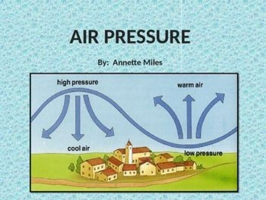
Air Pressure
Understanding Air Pressure
-
Air has weight and exerts pressure due to gravity.
-
Measured in millibars: Average sea-level pressure is about 1,013 millibars.
-
Above 1,012 mb: High pressure
-
Below 1,012 mb: Low pressure
-
Altitude and Pressure
-
Pressure decreases with height since there’s less air above.
-
Air is compressible: it contracts under higher pressure and expands under lower pressure.
Mapping Air Pressure
-
Isobars: Lines of equal pressure on a map.
-
Pressure values are reduced to sea level before mapping, just like temperature adjustments.
Conclusion
Air temperature and air pressure are foundational elements of weather and climate. Their behavior is influenced by the sun’s radiation, the shape and tilt of the Earth, altitude, and geographical location. Understanding these elements helps us interpret climatic differences across the globe—from the snow-capped mountains near the equator to the frozen tundras near the poles, and from coastal breezes to continental extremes.
Furthermore, the interplay between temperature and pressure drives wind systems and ocean currents, shaping the weather we experience daily. By grasping these principles, we not only gain insight into natural processes but also improve our ability to adapt to changing climates and plan human activities more wisely.