


Coastal Geomorphology: Understanding Wave Action, Erosion, and Deposition
Explore coastal geomorphology, including wave action, erosion, and depositional landforms. Learn how waves shape coastlines through processes like hydraulic action, abrasion, and deposition.
What is a coast?
A coast refers to that part of the land, which borders the sea, or any other extensive tract of water like seas and oceans. The character of the coastlines depends on the interaction of three main processes;
1. Wave action
2. Sea level changes
3. Coral reefs
WAVE OR MARINE ACTION
What are waves?
Waves are oscillatory movements of water particles in the sea or lake in that the surface of the water body is deformed into troughs and crests. The majority of the waves are formed by friction between the wind and the open surface of the water which causes the oscillation of the water particles. As the wind blows, a frictional drag develops at the place of contact between the wind and water, forming waves which push forward in the direction of wind movement. As the strength of the wind increases, so does the frictional drag and the size of the waves. Waves are however generated by other causes as well. The Japanese use the term tsunami to refer to a class of abnormal sea wave that can cause catastrophic damage. Such waves are generated by an under-sea earthquake, an under-sea landslide, or by an eruption of an under-sea volcano.
As waves approach the shallow water near the land, the crest overrides its base and the waves break forward as a swash. The momentum of this water has a sufficient force, which affects the coastline. The strength or energy of the waves is determined by three main factors; wind speed, the fetch and time.
The stronger or faster the speed of the wind the stronger the waves generated. The fetch is the distance of open water over which wind blows in order to generate waves. The longer the fetch the stronger the waves are likely to be. The time taken during which the wind blows also affects the strength of waves. The longer the time the more stronger the waves are likely to be.
Types of waves
There are two main types of waves;
Plunging waves
These waves are also referred to as strong waves, erosive waves, storm waves or destructive waves. They are characterized by the following:
· Strong backwash. The water having been thrown to the coast returns to the sea with much force thus eroding materials from the coast to the sea.
· They have a high frequency, one following another in a rapid succession at a rate of about 12to 14 waves a minute.
· High crest.
· Deep trough.
Spilling waves
Spilling waves are also referred to as weak waves, depositional waves, swell waves and constructive waves. They are characterized by the following:-
1. Strong swash or send. This is a powerful forward movement that pushes materials up the coasts and deposits them there.
2. Weak backwash such that the deposited material cannot be easily washed back to the sea. They have a low frequency of about 6 to 8 waves a minute.
3. They have a low crest and shallow trough.
The waves therefore have two major effects on the coast; eroding it or depositing material on it. There are therefore two major groups of landforms along the coast i.e. erosional and depositional landforms.
WAVE EROSIONAL LANDFORMS
Wave erosional landforms result from the action of plunging waves. These waves erode the coast in the following ways;
Hydraulic action
Water thrown against a cliff face by a breaking wave causes air and water in cracks and crevices to become suddenly compressed. When the wave retreat the air expands often explosively. This action when repeated constantly over a long period causes rocks to shatter as the cracks become enlarged and extended.
Corrasive action or abrasion
In this process, a mass of fragments such as boulders, pebbles and sand are thrown with great force (hurled) against the coast e.g. the base of a cliff by breaking waves and this cause’s rock break up.
Solution or corrosive action
This is ability of water to dissolve some rocks. For example, limestone and rock salt are easily dissolve in water resulting in wearing away of the coast.
Attrition
This involves the mutual wearing down of materials such as boulders, pebbles and other rock fragments carried by the water so that they become reduced in size. This happens when the materials carried by waves constantly knock against each other.
Landforms resulting from wave erosion
The landforms resulting from wave erosion include cliffs, wave cut platforms, caves, blow holes, geos, peninsular, bays and headlands, arches and stacks.
Cliff
Cliffs are steep slopes or rock faces along sea or lake coasts found above high tide level. They may be vertical or slanting. Most coastal cliffs are formed when strong waves cut notches at about high tide level of the coastline. Notches are small opening formed by the undercutting of the coast by the hydraulic, abrasive and solvent action of waves. Notches mostly develop where there are well-developed limestone rocks and where rocks have cracks or joints. Example of notches can be found at the Kilindini harbour entrance and Mtwapa.
Continued wave erosion by the hydraulic, abrasive and solvent action of waves in combination with weathering and mass wasting causes the notch to enlarge, resulting in it collapsing and retreating to form a cliff e.g. at Fort Jesus near Mombasa, Watamu coast and Allidina Visram High school in Mombasa, Fort Garaza near Kilwa, at Kasenyi at the shores of Lake Victoria near Entebbe, as well as at Lutembe and at Botanical gardens in Entebbe.
Illustration
Wave cut platforms.
Wave cut platforms are bench like features sloping seaward below the cliff. They form between low and high water tide zones. The continued under cutting of the cliffs through abrasive and hydraulic actions of waves, combined with sub-aerial mass movement causes the upper parts of the cliffs to collapse and slowly retreat. As the cliffs retreat wave-cut benches form through the grinding action of materials swept back and forth by the breaking waves. In time, the benches are enlarged into wave-cut platforms. They are visible at low tide and covered by water at high tide e.g. at Tiwi beach at Dar es Salaam and south of Mombasa in Kenya. The Oceanic Hotel at Mombasa is built on the wave-cut platform.
Bays and headlands
Bays are also known as gulfs, bights and coves depending on their size. A bay is similar to, but usually considered to be smaller than, a gulf. The Gulf of Mexico, for example, contains numerous bays. Bight on the other hand is a very wide bay. The Bight of Benin in West Africa extends from the mouth of the Volta River to the mouth of the Niger River and measures 720 km long.
Bays and headlands are indented coasts with bays forming where water projects into the adjacent land while headlands form where land projects into the adjacent water. They develop where resistant and weak (less resistant) rocks alternate and lie at right angles to the coast.
The weak rocks are worn down to form bays while the resistant rocks stand out as headlands. Several bays are found along the shores of Lake Victoria such as Kavirondo, Homa, Karungu in Kenya, Speke and Emin Pasha Gulfs in Tanzania, Napoleon, Sango, Murchison, Buyaga, Berkely and Kibanga bays in Uganda. The bays along the East African coast include those at Mombasa, Watamu and Malindi in Kenya, Tanga, Oyesterbay and Msasani bay in Tanzania. Headlands include Entebbe and Mweya peninsulas.

Caves
Caves are hollows beneath the surface of the earth or in the side of a hill, cliff, or mountain. Caves vary in size and shape, and many have large openings to the surface. However the caves we are interested in are the sea/lake caves, which are formed by wave action against seaside or lakeside cliffs. Lake or sea caves are cylindrical tunnels found at coasts especially at the base of cliffs. They develop where waves through hydraulic, abrasive and solution actions enlarge initial weakness in the rocks especially along joints, faults and bedding planes.

The force of breaking waves compresses air in cracks and crevices and as they retreat, the trapped air suddenly expands and exerts pressure within cracks causing weakening and breaking up of rocks. Most caves form in this way e.g. along East African coast especially at Shimoni, Funzi Bay, Tiwi beach, Kalifi and Watamu along the Kenyan coast and at Oysterbay in Dar-es-Salaam. Caves are also common along the shores of Lake Victoria near Botanical gardens and Nsamizi in Entebbe, and Lutembe beach.
Blowholes or gloups
A blowhole is a vertical tunnel connecting the cave roof with the cliff top. Hydraulic action within caves may create immense pressure, which may open up hollows through the roofs of caves. This is through the force of waves spurting high into the air hence weakening joint blocks in the cave roof. Blowholes include those at Mama Ngina Drive at Mombasa, Shimoni south of Mombasa, near Malindi and Watumu coast as well as the Lesouffer blowhole south of Reunion.


Geo
A geo is a deep, narrow, steep sided inlet in the cliff. It is formed when the entire roof of the c collapses due to wave erosion along major joints or faults.

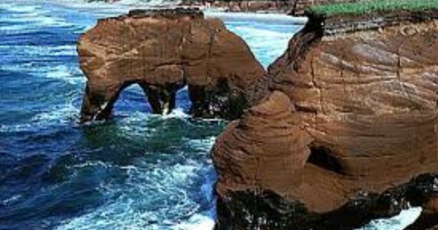
Arch, stack and stump
Arches are bridge-like features found above the caves. When caves develop on either side of a headland and ultimately join, they give rise to a natural arch. With continued erosion the arch may collapse leaving an isolated rock mass separated from the mainland known as a stack. The continued wave erosion of the stack may lower it to below water level or may be submerged at high tide to form a stump. Stacks occur between Malindi and Mombasa, the rock pillar stack near Entebbe airport and at Kasenyi fish landing site on Lake Victoria near Entebbe. An arch is found at Vasco da Gama pillar in Malindi.

MARINE TRANSPORTATION
The most important transporting agent of sand, pebbles and other materials along the coast are the waves. The swash and backwash push and drag material up and down the beach. The waves approach the coast at an oblique angle and move obliquely up the beach but the backwash runs back at right angles to the shore after depositing material. These two actions together constitute long shore drift. Wind must be added as a transporting agent,
MARINE OR WAVE DEPOSITIONAL LANDFORMS
Beach.
Beaches are gently sloping platform of sand, shingle or both along coasts. The materials making up the beach are transported and deposited along the coast by long-shore drift. Construction is most active during calm weather when relatively low waves break with a swash that carries materials up the coast. This material accumulates between the high and low water tides and therefore may be exposed at low tide or submerged at high tide. Beaches mostly form where the coast is low lying and vary is size from small ones to tens of kilometres in length. Examples of beaches include Nyali beach near Mombasa, Mombasa beach along the East African coast, Lutembe, Nabugabo, Lido, Gaba, Nabikonya and others along the shores of Lake Victoria.
Illustration
Berms, Beach cups and Beach rock
Several smaller landforms develop on beaches such as berms, beach rocks, beach cusps and beach ridges. Berms are benches or ridges with a steep front found on the upper part of some beaches.
Illustration
They develop on beaches with steep profiles that experience a high tidal range. Their formation is influenced by the size of the tidal range, where this is very large several berms develop. Large berms occur along the Tanzanian coast such as on the delta of River Wani and on the eastern shores of Lake Albert.
Beach cups are a series of small, horn-shaped projections separated by shallow indentations that face seaward. They consist of mainly sand and gravel and are common where large waves, which break frequent. The distance between two cusps is about 50 metres and they rise to about one metre above sea level. They are formed by eddies of a powerful swash scour coarse materials in the depositions. Beach rock is a hard crust-like deposit found on beaches. It is composed of sand, shells and pebbles deposited by waves and cemented together by calcium carbonate. In East parallel to the shore, east Africa, they are confined to the Kenyan coast.
Barrier beach
Barrier beaches are long sandy ridge of Islands lying parallel to the coast and separated from it by lagoons. They form on gently sloping coastlines by the deposition of materials by the long shore drift. The waves break off shore or before reaching the coastline thereby depositing the materials carried by them to form off shore sand bars. Further deposition by wave action increases the height of the bars barrier until they appears above sea level and. These deposits gradually migrate towards the land as a beach. They form along coasts, which are gently sloping, and with a fairly low tidal range. Lagoon coasts, with a coastal barrier beach backed by lagoons, are common between Liberia and Nigeria.
Illustration
Bay head beaches
Bay head beaches consist of a crescent of sand and shingle deposited by the long shore drift in bays between headlands e.g. beaches such as Lutembe, Botanical, Gaba, Bugonza and Lido around the shores of Lake Victoria.
Spits
Spits are embankments of sand, shingle or both, attached to the land at one end and extending seaward or across an estuary at the other end. Spits may be parallel to the coast or grow at a curved angle to the coast. They develop from the movement of materials by the long shore drift. When the long shore drift operates across a river mouth, a zone of slack water develops between the long shore drift and the river and any material carried by long shore drift is deposited.
The deposited material forms a spit. The main conditions necessary for the formation of spits is the presence of an ample long shore drift material, together with an irregular coastline. Examples of spits are seen at Kaiso andTonya along the shores of Lake Albert and the Ras Luale spit north of Dar-es-salaam.
illustration
Sand bar
Further erosion due to backwash can cut off part of the spit that trails out to the sea from the main land. This results into the formation of an offshore Island known as a sand bar.
Bay bars
Bay bars form where spits continues to grow lengthwise, and link the two headlands enclosing a lagoon and marshes e.g. Lake Nabugabo enclosed by Lwamunda swamp near Masaka was cut off from Lake Victoria by a bay bar.
Off-shore bars
Off-shore bars are ridges of sand, shingle, mud and gravel which lie roughly parallel to the coast. They form on shallow, gently sloping coats and irregular shorelines. The process of long shore drift causes the materials to be deposited by waves breaking a distance from the shoreline. Repeated processes lead to the accumulation of materials at the break point to form bars. Lagoons,mudflats and marshes often develop behind these off-shore bars.
Illustration
Tombolos.
Tombolos are ridges of sand, shingle and pebbles joining on island to the mainland. Most tombolos begin as spits but with continued deposition, they join pre-existing Islands to the mainland. The ideal condition for their formation is an ample supply of debris for wave deposition to form connecting ridges and a low tidal range such that the deposited material is not disturbed. e.g. the tombolos along the Kenyan coast near Gougoni north of Malindi and one which used to join Lambu Island to the mainland at Masaka in Lake Victoria. The tombolo in Masaka was destroyed in 1960 as a result of a heavy rains and a rise in the level of Lake Victoria.
| Topic | Key Facts |
|---|
| Definition of a Coast | A coast is the part of land bordering a sea, ocean, or large water body. |
| Processes Shaping Coastlines | Main processes include wave action, sea level changes, and coral reef growth. |
| Wave Formation | Waves are generated by wind friction on the water surface, creating oscillatory movement. |
| Factors Influencing Wave Strength | Determined by wind speed, fetch (distance wind travels over water), and duration of wind action. |
| Types of Waves | - Plunging waves (strong, erosive) - Spilling waves (weaker, depositional) |
| Erosional Coastal Landforms | Examples include cliffs, caves, wave-cut platforms, bays, headlands, blowholes, arches, stacks, and stumps. |
| Longshore Drift | The movement of sediments along a coastline due to waves approaching at an angle. |
| Depositional Coastal Landforms | Includes beaches, spits, sandbars, bay bars, tombolos, cuspate forelands, and mudflats. |
| Importance of Coastal Features | - Tourism & recreation (beaches, cliffs) - Fishing (lagoons, estuaries) - Sand mining (beaches) - Education & research (coastal formations) |
| Human Impact on Coasts | Activities like sand mining, pollution, and coastal development affect coastal geomorphology. |
Cuspate forelands
Cuspate forelands are large triangular-shaped deposits of sand and shingle projecting seawards. They are formed when two spits grow towards each other at an angle and coalesce enclosing a mass of water. The lagoons slowly silt up by continued deposition and the area soon becomes colonised by vegetation. The forelands are gradually enlarged by additional materials to form beach ridges e.g. at Point a Larree in Madagascar.
Mud flats
Mud flats form when tides and waves deposit fine materials such as silt along gently shelving coasts, which are sheltered, especially in bays and estuaries. The deposition of these silts together with river alluviums, results in the building up of a platform of mud called mud flats e.g. at Lamu, Tanga, at the mouth of River Rufigi and at Murchison Bay in Luzira at the shores of Lake Victoria.
Salt Mashes
When vegetation grows and spreads on the mudflats, the feature is known as salt marsh. The common vegetation in such areas is sea grass and mangroves, which help to trap silt e.g. at Lamu and Malindi along the Kenyan coast and Tanga, Dar es Salaam, Lindi and Mtwara along the Tanzanian coast.
Coastal dunes
These develop on coasts where winds are predominantly on shore, and are sufficiently strong to move a large supply of sand inland from a wide beach area. They are common along arid and semi-arid coasts e.g. along the south coast of Madagascar.
Value of wave action features
- 1. Beaches are used as recreational grounds e.g. Lutembe, Lido and Botanical beaches along the shores of Lake Victoria as well as the Mombassa beach along the Kenyan coast.
- 2. Mining of sand from the beaches e.g. at Kasenyi on the shores of Lake Victoria near Entebbe.
- 3. The features such as cliffs, headlands, and beaches attract tourists hence earning the respective countries foreign exchange.
- 4. Lagoon lakes such as Lake Nabugabo act as fishing grounds.
- 5. The features are used for research or study purposes.
- 6. Mud flats have been reclaimed for agricultural purposes.
FAQs
-
What is a coast?
A coast is the part of land that borders a sea, ocean, or any other large water body. -
What are the main processes that shape coastlines?
Coastlines are shaped by wave action, sea level changes, and coral reefs. -
How are waves formed?
Waves are mainly formed by friction between wind and the open water surface, causing oscillatory movements of water particles. -
What factors determine the strength of waves?
The strength of waves is influenced by wind speed, fetch (distance over which the wind blows), and duration of wind action. -
What are the types of waves?
- Plunging waves (strong, erosive waves)
- Spilling waves (weak, depositional waves)
-
What are some wave erosional landforms?
Examples include cliffs, caves, wave-cut platforms, bays and headlands, blowholes, geos, arches, stacks, and stumps. -
How do beaches form?
Beaches form from sand and shingle deposited by waves and longshore drift along coasts. -
What is longshore drift?
Longshore drift is the movement of sediments along a coast by waves approaching at an angle and retreating perpendicularly. -
What are some depositional coastal landforms?
Depositional features include beaches, spits, sandbars, bay bars, tombolos, cuspate forelands, and mudflats. -
What are the benefits of wave action features?
- Beaches provide recreational spaces.
- Tourism is boosted by coastal landforms like cliffs and headlands.
- Fishing thrives in lagoon lakes.
- Sand mining occurs on beaches.
- Research and education are supported by coastal features.